Web Analytics
Showing posts with label Burial. Show all posts

Saturday, June 26, 2010

Foot Prints of Pre-historic Men around Bhopal


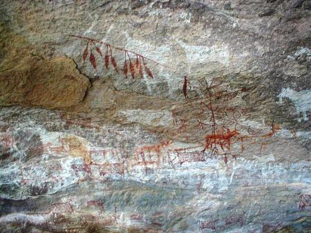
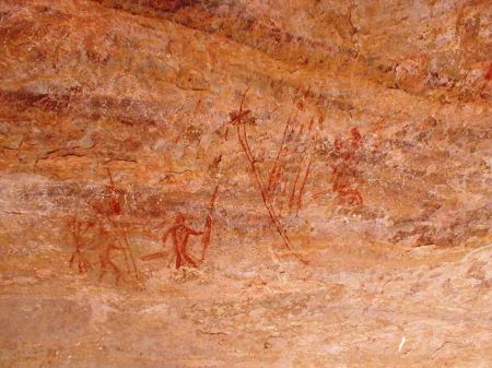
Foot prints of pre-historic civilizations are scattered all over the Indian Sub Continent but their abundance in Madhya Pradesh and Chhattisgarh is noteworthy. Rock Shelters and Cave Paintings at Bhimbetka near Bhopal are now world famous, thanks to UNESCO which has recognized them as a World Heritage site. Such paintings are known from Singhanpur (Kabra Hill) in Raigarh district, Adamgarh near Hoshangabad, in the nearby hills at Bijawar (Chhatarpur district), at Mrigendranath cave of Patni village of Bareli Tahsil (Raisen district),and again at Chidia Tol hills near Bhopal on Raisen Road. Very recently there were reports of rock paintings being destroyed in the mines near Budhni (Hoshangabad) and there was a great media cry. This prompted the administration to cancel the mining lease.

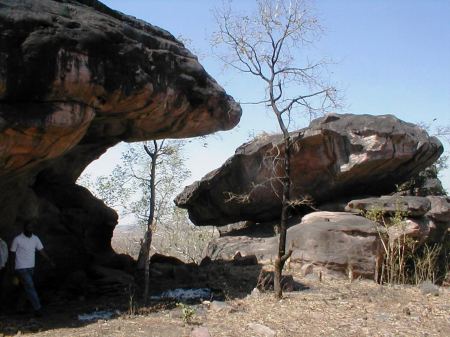
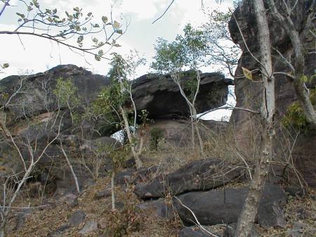
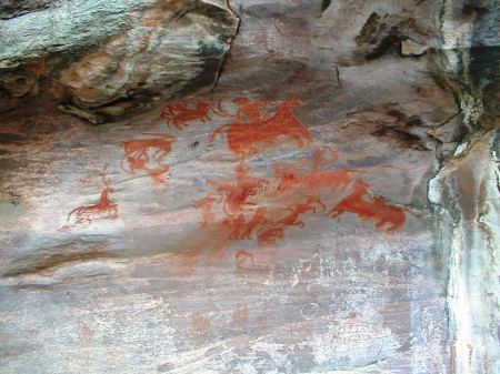
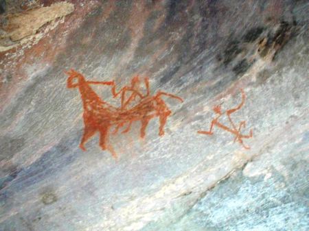
Closer to Bhimbetka at a distance of 5 kilometers there is another cluster of Rock Shelters known as Pengavan and the paintings occuring there are considered to be very rare. Their antiquity is between 10,000 to 35,000 years. It was also in the news that the hills running parallel to the Kolar Road of Bhopal also contain rock paintings. One Mr. Ashish Joshi, my neighbour, closely connected with the print media, happened to take us to yet another cluster of rock shelters which awaits to be discovered by an archaeologist of repute!. This is closer to the Kerva Dam where on a hill known as Ganesh Pahadi falling in the Samardha ranges, several rock shelters with beautiful paintings greeted us. Still farther from that spot at Madiakot, Mr.Joshi enthusiastically showed us a typical formation of a rock circle, believed to be the burial/sacred place akin to a Tumulus. It was around 70 meters in diameter. Very few people have noticed this so far and this is purely man made and not a creation of nature. A forest road through the newly developed picnic spot with tree houses would lead you there after traversing a distance of around 6/7 kilometers. However, one needs to have a jeep or bikes which can only carry you there.

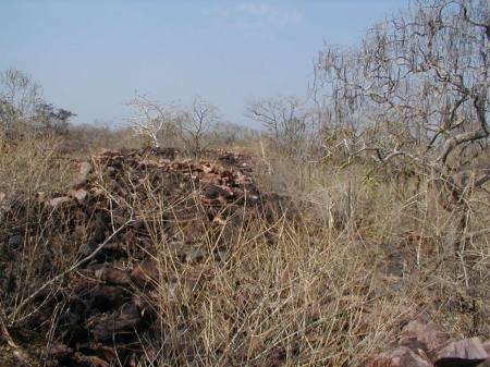
Once back at home, we also hunted for the stone circle for which Wikimapia and Google Earth came in handy. Yes the satellite maps clearly showed them. We were surprised to find one more small circle below (left) the larger one. It would be of interest to learn that the hills starting from Hoshangabad and going beyond Sanchi (North of Bhopal) have most of the rock shelters as also Buddhist Stupas. It is quite possible that the stone circles could have been the abandoned foundations of Stupas. We believe a deeper study of the terrain coupled with trial excavations is required to come to any meaningful conclusions.

The Eco Tourism Development Board of Madhya Pradesh has been hunting for such hidden treasures lying deep in the forests. For the past few years they are engaged in developing necessary infrastructure at such destinations so as to promote ecotourism. Close to Bhopal they have also identified Samardha village as their epicenter for extensive development. On the other hand the Forest Department, with a view to promote environmental awareness has constructed several tree houses and cottages close to the Kerva Dam near Bhopal. They also arrange trekking and mountaineering expeditions periodically. Incidentally ecotourism is not yet recognized as a forestry activity, although it is a means of conserving forests by increasing visitation and generating awareness. Under this umbrella, ecotourism can be a forestry activity, ancillary to conservation. For greater impetus the Government of India need to take steps to bring in suitable amendment to the Forest (Conservation) Act, 1980.

Friday, September 19, 2008

Bartia Bhata - Megalithic Burial Ground

To cover my operational area, I was required to travel frequently visiting various centres. While visiting interior centres, I used to travel by a Jeep or a sturdier vehicle and also carry a "Topographic Sheet" (toposheet) of a larger scale (published by Survey of India) relating to the area of my operation. They contain detailed information about fortifications, ruins, temples, hillocks, rivers and rivulets, bridges, ponds etc. which proved very useful for me. Today we have the Google Earth which also gives a satellite view of the land surface sans description. Wikimapia is another facility where you are enabled to identify places/objects and mark descriptions of your own.

Once I was required to visit a far off village known as "Gatadih" in Raipur district. To reach the place I needed to travel upto Saraipali, at a distance of 145 km's on Raipur - Sambalpur highway (Great Eastern Road) and then take a left turn towards the North for another 30 km's or so. The road to Gatadih was once made of bitumen but in the absence of maintenance, developed hundreds of potholes. It was impossible to drive without stumbling on them, giving terrible bone shaking jerks. Nevertheless, I reached Gatadih after a 2 hours ordeal, with every part of my body aching.

After finishing my usual inspection of the office thereat and scribbling my observations, it was time for me to return. The very thought of the return journey brought shivers in my spines. After resting a while, I pulled out my toposheet and spread it on the bonnet of the Jeep. On examination, I found, there was a kutcha road which could take me to the highway, leaving behind Saraipali, at a place known as Basna. Midway there was a large village "Bhanwarpur". I consulted some locals, who were assembled near my Jeep, and decided to take the unexplored road. The driver of my Jeep too was enthusiastic. Instead of going straight to Saraipali, we took the road to the right coming at a short distance. We traversed through the country side on the sparingly metalled road till we were about to reach Bhanwarpur.

While looking out of the window, I came across an unusual land formation on the right. The barren ground was strewn with pillar like monoliths. I gestured the driver to stop the vehicle on the roadside and walked towards the ground for a closer appreciation. In no time I found myself surrounded by a meter high monoliths all around. All the stone pillars were in a slanting position. One was even lying flat, on which I sat for a while. They were more akin to menhirs. I felt a sensation when I realised that it is a Megalithic burial ground. My "Steffy" ( Doggy - Fox Terrier) started making noises as if to tell me to make a move.

On one side of it, adjoining the road, there was a small building housing the Tribal Hostel. There was a guy available there with whom I conversed. He narrated that long long ago a marriage party was resting on these grounds and due to certain reasons they all became stones. That is why the place is known as "Bartia Bhata". A barren plain land is referred to as "Bhata" in the Chhattisgarhi dialect. He also informed me that during the excavations for the foundation of the building some pots, iron articles like knives, arrow heads etc. were found under the soil. He could not positively say if any skeletons were found.

On my return to Raipur, I took up the matter in the District Archaeological Committee meeting emphasizing the importance of the place and the need to protect it and conduct extensive excavations so that we are better informed about the cultural aspects of the tribal life. Subsequently a survey was conducted and I learnt that the site is around 2 to 3000 years old and nothing more. Similar sites have also been encountered one each in Durg and Dhamtari districts but the one at Bartia Bhata is said to be the largest.