Web Analytics

Tuesday, September 14, 2010

Wayanad (Kerala), worth visiting

Guest Post by my brother
P.N. Sampath Kumar,
Cochin Shipyard, Kochi.

Our family outing is normally during our son’s vacations for Onam, Christmas and summer holidays. We had originally scheduled a trip to Colombo and Kandy but could not make it as we had only 4 days available, which we thought will not be sufficient for a proper trip through Sri Lanka.

Wayanad came to our mind as it is a mixture of nature and history. Biodiversity is the richest.  From Ernakulam (Kochi), we had two options to travel, either via Nilambur by own car or via Kozhikode (Calicut) by a combination of Train and Bus. We chose the Calicut route and decided against driving own car considering difficult weather and unknown terrains. We booked a room in a budget Resort called Haritagiri, located at Kalpetta as we had a  reasonably good feedback.

The Tali temple
We took an afternoon train to reach Calicut by evening. We had only one night to spend and hence decided to limit our visit to the beach (not the one Vasco-da-gama once landed, which is called Kappad Beach) and the Tali Temple. Calicut has a good beach, plenty of mosques and a very famous temple called “Tali”. Tali probably means a place where the kings used to take decisions on issues. Moreover Tali temple used to be the venue for scholarly debates in the olden  days. “Uddanda Shastrigal” from Tanjavur has once won the title by defeating others in Tarka Shastra (Logics) which used to be the test of knowledge those days. This Temple was built by Swami Thirumulpad (Zamorin) within his palace complex in the 14th century.  

There are only few choices for hard core veggies in Calicut; one such restaurant is “Dakshin” where we tried some Dosas.

There are plenty of buses operating between Calicut and Wayanad. The journey took 2.30 hrs through the mountains called Tamarassery Pass to reach Kalpetta. The Tamarassery pass has nine hairpin bends (our son counted all of them) and most of the time it will be foggy. It was really an enjoyable experience traveling through the wild.

Wayanad borders both Karnataka and Tamilnadu. There are three major towns in Wayanad which are are Kalpetta, Mananthavady and Sultan Battery. Majority of land is in the form of forest and the rest are either plantations or paddy fields. Coffee is abundantly cultivated. Wayanad ginger, Turmeric, lemongrass and honey are very famous in Kerala for their quality and flavour. Weather is cool round the year. Majority population are migrated farmers from elsewhere in search of fortune. It is said that the local tribals with their archery skills and guerilla warfare techniques supported Pazhassi Raja who fought the British in the 17th century. Pazhassi Raja’s tomb is situated at Mananthavady.
Haritagiri Resort
 Haritagiri is a good resort having a small swimming pool, bar, restaurant and an ayurvedic spa. Veggies will find it difficult to have a lunch in that restaurant as most of the cuisines are non vegetarian. There are resorts catering to the needs of different food habits. But we tried to explore small time eateries who serve proper vegetarian food. There are a couple of vegetarian messes run at Kalpetta. We tried one Swami’s mess in Kalpetta town run by an old Tamil Brahmin couple where we had a very good lunch with traditional north Kerala Brahimn recipes. One of the curries was made of dried jackfruit nut.

It is better to hire a tourist taxi to visit the spots in and around Wayanad. We hired a Tata Indica for 1½ days and they charged Rs.2700/-. For trips covering 4-5 KMs, etc.,It’s  better to hire an autorikshaw which we found to be very cheap here. I have never paid more than Rs.10/- for a trip here. People are very friendly and so are the drivers.

The must visit places in Wayanad (according to tourist operators there) are Kuruva Dweep (which was closed then due to heavy rain), Chembra peak, Pookode lake, Muthanga Wild life sanctuary, Thirunelli, Pakshi pathalam, soochipara water falls, etc. But in consultation with our driver cum guide, we chalked out our own plan. He took us to take half way through the Chembra peak (6900 feet above sea level) up to where it is navigable by road. There is a watch tower up to which we went. The sight of the valleys of tea and coffee estates as also the  view of Kalpetta from a distance was enchanting. Our son was happy for having been kissed by the clouds and was busy collecting pieces of clouds and put them in his shirt pocket.

The Chembra Peak

Towards Chembra Peak
Half way through Chembra Peak
It takes at least half a day to finish this if you want to trek to the top. Ideally you need to have a small like minded group of 7-8 people, equipped with safety gadgets, water, food, etc. Half way further to the top, they say there is a heart shaped lake on the bank of which people take rest, drink water and have food before they climb further upto the peak.All these reminded me of the great Mana Sarovar and Kailash. We have consigned  it for  the next time
.
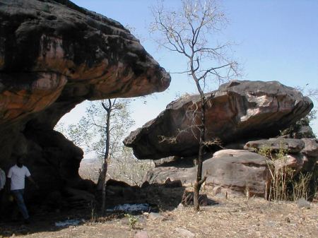
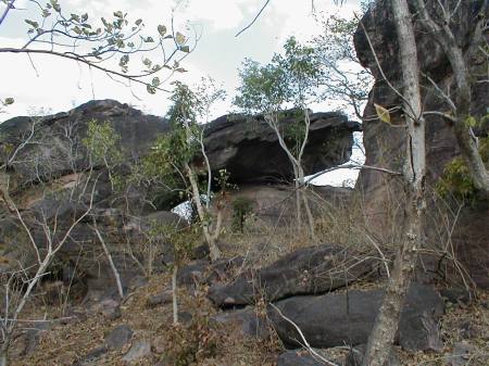
Our next destination was Edakkal caves, they are two natural caves located 1000 metres high on Ambukutty Mala (Hill) 25 km from Kalpetta  on the way to  Sultan Battery. They lie on an ancient trade route connecting the high mountains of Mysore to the Malabar coast ports. These  caves were discovered by  Fred- Fawcett, the then superintendent of police of the Malabar District, who was on  a hunting trip to Wayanad in 1890. Our travel was through village roads and took an hour to reach the spot.

Way to the caves
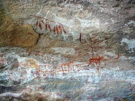
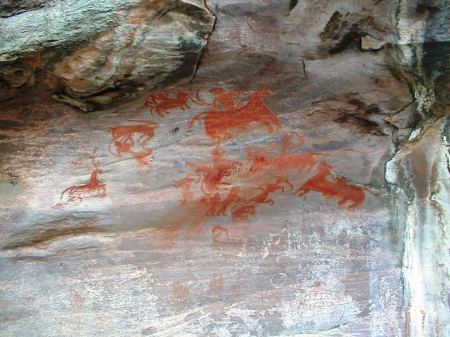
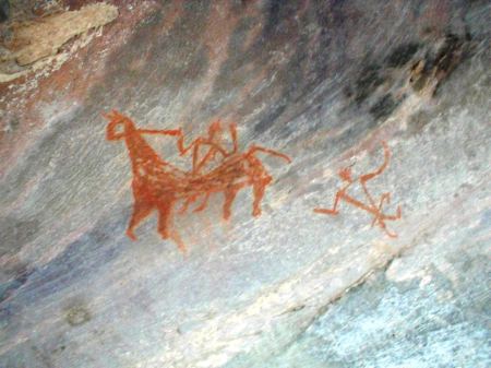
A beautiful Petroglyph
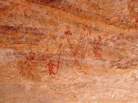
The cave is on top of a hill and one has to trek about 200 -250 meters steep to the top which requires a bit of mountaineering skill. We saw plenty of tourists visiting this place without much taste or understanding of history. There are carvings considered to be of BC 2000-6000 period (Neolithic i.e.stone age). The Kerala Archeological department maintains it and charges a little fee. Photography is allowed inside the cave. There are few pictures and some scripts engraved on the walls (Petroglyphs) of the cave. The pictures that we could make out were of a deer like creature and a human face with ornaments of possibly a tribal chief.  It took us about 2 hours to finish. Short Tamil Brahmi inscriptions datable to around 3rd Century CE have also been discovered in these caves, the fifth one reading "Sri Vazhumi" is the latest discovery by M.R. Raghava Varier, retired Professor of Epigraphy, Calicut University (February 2012 update).
Photo by: Mohammed A
The nearest town to Edakkal Caves site is Sultan Battery. Further from the town towards the Boarder of Karnataka situates the Muttanga wild life sanctuary. Like all sanctuaries the best time to visit the park is early morning. There are four wheel jeeps available on hire with a guide inside the sanctuary. We reached the place in the evening and could sight few deers and peacocks. In the morning elephants and bisons are sighted more often and if you are very lucky, even tigers could be encountered. The sanctuary borders both Tamil Nadu and Karnataka.


The pookode lake is the most beautiful lake that we have ever seen in Kerala; resembles Nainital. This is located near a place called Vythiri. It is a natural lake in the midst of hills. Boating in the lake or walking around the lake is the major activity here.
Kanthanpara falls, the safe one.
Kanthanpara fall
We avoided Suchipara falls because of the  distance and chose a nearby fall called Kanthan para (lesser known to outside world) as suggested by our guide. It is a small fall in two stages. The first one is safer as it forms a pond where even children can safely play. Wayanad has a number of such un-spoilt spots.
At Kanthanpara
Next day, we took a bus to travel to Tirunelli and Papanasam fall. One need to take a bus to Mananthavadi first and then to Tirunelli. Overall it takes 2 ½ hours to reach the temple. The route was exciting with views of the wild and occasional housing colonies of the tribal community beside the paddy fields. The road is through the proposed Elephant corridor. Not to mention, elephants are often sighted here on the road / road side. We found few deers.

The temple is dedicated to Lord Vishnu is surrounded by mountains and looks like Sabarimala temple. The temple looks very old. They say that there are mentions about this temple in the 10th century literatures. Tirunelli used to be an important town till 16th Century, along with Kodungallur and Mangalapuram. The temple is not architecturally very beautiful. When we visited, the inner side of the temple was getting renovated with teak wood roofs.The only interesting part I could notice is the plumbing arrangement made of granite stones to provide water to the temple from a distant mountain.
Tirunelli temple and the aquaduct
People visit Tirunelli for two reasons; one to take a dip in the nereby stream called Papanasam and two, to consult tribal physicians practicing tribal medicine. In Papanasam pond (which is called brahma theertham), we found a carved stone in the middle depicting Sankhu, Chakra and Gada of the Loard Vishnu, where some poojas are offered. This also looked to be very old.
Papanasam (Where sins are washed away)
Symbolic representation of Lord Vishnu
We returned to Ernakulam the third day via Calicut. Wayanad has a lot to offer for someone who is ready to walk and trek a lot. Good people blessed with good weather and nature.

Monday, September 6, 2010

There was a strange visitor at home


This happened on the 21st August. I was preparing a post for my Hindi Blog and it was already half past ten at night. Suddenly I heard my son calling me and there was a kind of emergency in his tone. I ran down and found him pointing towards the main entrance. There was a curled snake lying between the door and the wall. It so happened that he was about to close the main door when he spotted the reptile. I pacified him and suggested not to panic. I asked him to bring the camera, to which he retorted, what dad, there is a snake in the house and you want to have a photo session. He did bring the camera and I took few snaps randomly.


Because of the noise from my house, my immediate neighbor dropped in and got scared. Then there was an influx of young and old with sticks and all that. I requested people not to hurt the creature which has factually strayed in seeking shelter. The same snake was spotted  a day earlier at night in front of the main gate of a house adjacent to mine, remaining closed.  Up to midnight people were hunting for the poor thing but it could escape un hurt.

I had some basic  ideas about the Indian Snakes but the common view emerging from the small gathering of people from my campus was that it was a Python. In that case I would have ventured to catch it by its head and put it in a sack. When I had a closer look and particularly when it moved its head, it occurred to me that this is the deadliest variety, a Viper, referred to as Russels Viper. It is also sluggish but when threatened  could become extremely agile and attack. Among all the Indian Poisonous snakes, Viper’s venom is deadliest as the venom required to kill a person is the least when compared to Cobra and Krait. However, normally, they  do not attack humans and it also does not inject the fatal dose required for a human to die of the bite. As compared to this the Cobra injects a much larger quantity of venom per bite.

At my request, the snake catchers were summoned. They came in their van. Pretended to be scared of catching it telling people around that they can catch cobras by hand but not this one. This spits venom, very very dangerous and so on. Then they asked for a large container with a lid, which was provided. The Viper was not willing to get into the trap. It moved forward but obstacles were created and finally it was in the container with lid tightened with a rope. We heard its angry hissings. It was thus taken away providing the relief we needed but at a price.

Thursday, August 12, 2010

From my Court Yard

While through out the country, there is heavy rainfall causing widespread destruction to life and property, we had been waiting for the clouds to turn to us. At last we were favored in some small measure. The various plants in my court yard are in bloom expressing their happiness. You may provide their names as I feel I am botanically challenged!

Adenium (Desert Rose)
Rose (Rishi)

Violet Trumpet vine


Hibiscus Miniature (1.5 centemeters)

Button Rose (Miniature)

Rose
Miniature
Parijat - Harsingar, Tree of Sorrow (Nyctanthes arbortristis)

Madhukamini

 Ixora Yellow

Thursday, July 15, 2010

Fascinating Millipedes

Recently A Wandering Mind carried some pictures of the insects mushrooming after the onset of monsoon in Mumbai. Among them there was the scary hoard of centipedes whose one sting would make you weep for hours together. Then I recollected the mild and sober Millipedes, I had photographed while we were at our native place, that is Kerala, during May this year.
See how inquisitive Siddharth  is
On being dropped on the ground
When it was finally released and relieved
One day I found my nephews engaged in some serious exploration in the garden surrounding our ancestral home. They were playing with something, they discovered. Since they were either from Mumbai or Chennai, they were deprived of being closer to nature. While at our home, they had the opportunity of seeing things, their text books talked about. I had a notion that children brought up in cities are devoid of any inquisitiveness but I was proved wrong. Children are  children and they have it ab-initio.

Millipedes, literally means "thousand-legged," although most millipedes do not have  more than 300 legs,are found in all temperate and tropical regions of the world. They rest and hide among leaf fall, soil, or anything rotting for they survive on dead and decaying plant matter. Most species of millipedes are said to be  nocturnally active but in Kerala I found them moving around even during day time. Apart from the ones shown above, I have encountered Millipedes which are pink and dark brown in appearance. Looking them when they are on a move is a real pleasure. They are so majestic.The rhythmic movement of hundreds of legs is worth a watch.

As a means of protection, millipedes have developed unique defense mechanisms for survival. One strategy is to curl up into a spiral. This coil protects the millipede's head and soft underside. Some species of millipedes can also secrete a foul-smelling/terrible tasting fluid through glands located alongside their body, near the legs on each segment. The toxicity of this fluid varies from species to species. For example, the excretions of some species can discolor human skin or irritate the eyes, others are corrosive, and some species even produce cyanide that can repel or kill insect predators.

Wednesday, July 7, 2010

Pit Elephants (കുഴി ആന)

This summer we were in Kerala  to participate in a family function. It was extremely humid and hot and there seemed to be no end to sweating and that too quite profusely, despite all the greenery. Kerala summers were never that harsh, thanks to Global Warming. 

Before dropping the Ant

After dropping an ant
One afternoon, I was just loitering around my  ancestral home. I came across some familiar soil formations on the sides of the pathway. Instantly my childhood memories came alive. They were the Sand Pit Traps laboriously created by “Ant Lions”, a term I have borrowed from wikipedia, but we knew that they are the abodes of “Kuzhi Ana” (കുഴി ആന) or literally “Pit Elephants” as they had  long noses. They are a bit different from the one wikipedia describes. The tiny, elephant like insect, used to position itself under the sand awaiting its prey which were usually the ants and other tiny insects. Myself and my sisters used to dig up the pits to catch the insects (Elephants!). Thereafter we used to amuse ourselves by organizing a race for those tiny creatures. Every one of us  used to shout to cheer up one’s own Elephant! as if we are in a horse race.   

.
Upon spotting the Sand Pit ant Traps, I could not resist the temptation of showing a live demonstration to children at home. They were summoned and a camera was brought in, an ant was caught and put in the hole. Lo! the ant just disappeared. The Antlion or our Pit Elephant living under the sand just dragged its prey in, in   a fraction of a second. There was only a depression in the cavity left behind. We could not, however, photograph that particular action. We should have applied the video mode instead.
http://www.youtube.com/watch?v=VvWsLrxTCQg

Saturday, June 26, 2010

Foot Prints of Pre-historic Men around Bhopal


Foot prints of pre-historic civilizations are scattered all over the Indian Sub Continent but their abundance in Madhya Pradesh and Chhattisgarh is noteworthy. Rock Shelters and Cave Paintings at Bhimbetka near Bhopal are now world famous, thanks to UNESCO which has recognized them as a World Heritage site. Such paintings are known from Singhanpur (Kabra Hill) in Raigarh district, Adamgarh near Hoshangabad, in the nearby hills at Bijawar (Chhatarpur district), at Mrigendranath cave of Patni village of Bareli Tahsil (Raisen district),and again at Chidia Tol hills near Bhopal on Raisen Road. Very recently there were reports of rock paintings being destroyed in the mines near Budhni (Hoshangabad) and there was a great media cry. This prompted the administration to cancel the mining lease.

Closer to Bhimbetka at a distance of 5 kilometers there is another cluster of Rock Shelters known as Pengavan and the paintings occuring there are considered to be very rare. Their antiquity is between 10,000 to 35,000 years. It was also in the news that the hills running parallel to the Kolar Road of Bhopal also contain rock paintings. One Mr. Ashish Joshi, my neighbour, closely connected with the print media, happened to take us to yet another cluster of rock shelters which awaits to be discovered by an archaeologist of repute!. This is closer to the Kerva Dam where on a hill known as Ganesh Pahadi falling in the Samardha ranges, several rock shelters with beautiful paintings greeted us. Still farther from that spot at Madiakot, Mr.Joshi enthusiastically showed us a typical formation of a rock circle, believed to be the burial/sacred place akin to a Tumulus. It was around 70 meters in diameter. Very few people have noticed this so far and this is purely man made and not a creation of nature. A forest road through the newly developed picnic spot with tree houses would lead you there after traversing a distance of around 6/7 kilometers. However, one needs to have a jeep or bikes which can only carry you there.

Once back at home, we also hunted for the stone circle for which Wikimapia and Google Earth came in handy. Yes the satellite maps clearly showed them. We were surprised to find one more small circle below (left) the larger one. It would be of interest to learn that the hills starting from Hoshangabad and going beyond Sanchi (North of Bhopal) have most of the rock shelters as also Buddhist Stupas. It is quite possible that the stone circles could have been the abandoned foundations of Stupas. We believe a deeper study of the terrain coupled with trial excavations is required to come to any meaningful conclusions.

The Eco Tourism Development Board of Madhya Pradesh has been hunting for such hidden treasures lying deep in the forests. For the past few years they are engaged in developing necessary infrastructure at such destinations so as to promote ecotourism. Close to Bhopal they have also identified Samardha village as their epicenter for extensive development. On the other hand the Forest Department, with a view to promote environmental awareness has constructed several tree houses and cottages close to the Kerva Dam near Bhopal. They also arrange trekking and mountaineering expeditions periodically. Incidentally ecotourism is not yet recognized as a forestry activity, although it is a means of conserving forests by increasing visitation and generating awareness. Under this umbrella, ecotourism can be a forestry activity, ancillary to conservation. For greater impetus the Government of India need to take steps to bring in suitable amendment to the Forest (Conservation) Act, 1980.

Tuesday, April 20, 2010

Kanheri Caves (Mumbai)


Several years ago while trying to locate the footprints of the Satavahana rule in Dakshina Kosala, I learnt about their inscriptional evidences  at Kanheri, Naneghat and Nashik (Pandav Leni) rock cut caves. I was curious to visit these holy places of the Buddhist regime, from that time onwards, so as to spend some moments living in the ancient past.
 
Although I have visited Mumbai numerous times, my friends over there were either reluctant or uninterested to take me to Kanheri (Krishna Giri) which was otherwise comfortably reachable. Last year during a routine visit to Mumbai I made up my mind to visit Kanheri Caves by myself. Moreover, my son was also with me. Incidentally my younger brother in law got enthused to accompany us. On one morning after breakfast, we three of us, boarded a suburban train from Dadar (West) and landed at Borivli within 30/40 minutes. Fearing that we may have to remain hungry, we located a good restaurant and had our fill. While we were out of the restaurant, we spotted a vacant auto which took us to the main gate of the Sanjay Gandhi National Park. We got inside the main gate after buying the entry tickets. We were happy to see a Tourism Development Corporation bus parked inside, which takes people to the Kanheri Caves, situated 6 kilometers deep inside the park. Unfortunately there were few people around  and the driver bluntly told us that the bus wont move unless there are adequate number of passengers. We were loosing time. Fortunately a van entering the park stopped by our side and offered us a lift for Rs.100. We readily agreed and boarded the van. The vehicle entered the dense forest winding its way through the lush greenery. The surrounding flora and fauna and the forest smell was a feast to our eyes and nostrils. Well here is a place in Mumbai where people can breathe fresh air and revitalize themselves. Within 10 minutes,  there appeared a hoarding of the Archaeological Department with a booth dispensing entry tickets. We were dropped at this point asking us to be back within 2 hours. The vehicle then pulled itself to the parking place. We bought the necessary tickets and took the stairs carved out on the surface of  hard volcanic rock.

Kanheri is the largest Buddhist site in India  in terms of the number of caves made in a single hill.  In the western part of India, Buddhism was introduced at Sopara which was once the capital of Aparantaka (North Konkan) way back in the 3rd Century BC. From that time onwards Kanheri being closer to Sopara was developed as a seat of learning for the Heenayana branch of Buddhism. Later it also continued to play its educational role for the Mahayana branch as well. Its history spans from as early as 3rd Century BC to as late as 11th Century AD. That makes it a unique site  that has gone through the rise and decline of Buddhism in India. The earliest rock cut cells, devoid of images or any other ornamentation, dates back to that period of Heenayana form of Buddhism. On the other hand the cells and Viharas (monasteries) with Buddha’s images and other designs belong to the Mahayana cult. Chiseling the hill and making monasteries etc. has however  continued up to the 9th Century AD.

Having completed climbing our first phase of the stairs. we found ourselves in a relatively leveled ground with the rock cut structures staring at us. At first sight we had a notion of having seen similar structures elsewhere. Then we recalled the Petra in Jordan which we never visited but had seen them through movie clips/photographs.There were many people exploring that particular structure. We also proceeded in that direction. It was a Chaitya Griha.
 This top one  is  at Kanheri
 This is the one at Karla (Lonavla)
Outwardly it did not look ornate but when we entered, it was a stunning experience. At the point of entry itself, there stood two Buddha’s on either side of the porch. They are supposed to be the tallest images in India.  A very large hall with an arched  roof (barrel vaulted) at the end of which there was a stupa with a semispherical top, the object of worship in the Chaitya. There were ornate pillars on either side. I loudly said “I shall cherish this experience” to which my brother in law reminded me of another such Chaita Griha at Karla near Lonavla. The Chaitya Griha there is said to be much more larger and beautiful. In fact it is the  largest cave Chaitya in India whereas the one at Kanheri is reckoned as the second largest.

Once after getting rid of my emotions/notions, I started discovering faults. Yes, the six pillars at the right end were simply square, there was nothing great about them. Also the pillars lacked symmetry. Anyway this was the place for the monks to meditate and referred to as Cave No.3. One of the most important ones at Kanheri. It is 26.36 meters long, 13.66 meters wide and 12.9 meters high. This was made during the reign of the Satavahana ruler Yajn Shri Satkarni (172 – 201 AD). However he was a Hindu ruler but was tolerant towards Buddhism or else he would not have funded this project. As an evidence he has left his inscription in Brahmi script of that period.

Two structural stupas existed near the Chaitya Griha (Shrine). One was built of stone and when dug up, it yielded two copper urns containing  ash, a small golden box with a piece of cloth, a silver box containing rubies, pearls, some golden pieces and a copper plate of the year 324 AD. The second stupa was built of bricks which yielded a stone slab bearing inscriptions in a script which was prevalent in the 5th/6th Century.

It seemed that we had spent considerable time at this chaitya Griha alone and realized that we need to speed up. We swiftly proceeded to the adjacent Cave No.1 which was planned as a two storied structure but remained unfinished. It has huge pillars. Next to it there was the Cave No.2, a small one. There is a stupa inside and the walls adorn Buddha as well as Avalokiteswara.
Cave No.1
Cave No.2
Though the cave clusters are scattered in random, many of them are aligned along some sort of terrace that makes it a common courtyard. The footpaths are connected from such cluster to cluster. In  many cases , especially as you proceed deep into the site, you've to scale the steps carved on the rocky surface to reach the caves. It dawned on us that we may not be able to see all that the place offers, for paucity of time. A fellow tourist advised us that apart from Cave No's.1, 2 and 3 Caves numbered as 11, 41, 67, 89 and 90 have sculptures carved on their walls. Therefore we hurriedly proceeded towards Cave No.11. This is referred to as the Darbar Hall. There is a stupa inside and on both sides there are Cells for residential purposes. Many viharas have benches and seats carved as integral part of the caves. Several inscriptions could also be encountered on its walls. Cave No.41 is said to be unique where Avalokiteswara is represented with 4 hands and 11 heads. Such an iconography of this sage is not obtainable anywhere in India. Avalokiteswara is said to have declined Enlightenment unless salvation of all the lesser mortals comes along.In the walls of Cave No.67 there are sculptures carved out representing the Jataka stories. 
Darbar Hall


Avalokiteswara
Inscription of Satavahanas
All these Cells and/or Viharas have a pillared verandah in the front. A cistern is located in the courtyard right next to the entrance of a cave. They served as water storage tanks for the daily use of the residents. We could  see the grooves and channel networks that direct rainwater to the cisterns. What is thus collected during the monsoon season could be preserved in the cistern for the summer. There are even some large open ponds excavated on the surface of the rock. Probably these served as community utility for bathing and washing clothes. Right beneath, at the cleft of two hilly formations is the remains of a dam. Here too the water stored was for community usage and for agriculture. A very beautiful example of water management by our ancestors.
Water Channel
There is a long stairway to the top of the hill, carved in the hard rock, in a superbly preserved condition. At the top there is a large cremation ground where the monks were being cremated. Number of structural  stupas, small and large made of bricks  reportedly exist there. However we had to contain our temptation and had to return from Cave No.67. When we were back at the parking site of our vehicle, we found the driver blowing up. 
Steps leading to the top of the hill
Again at Borivli we caught a local train to take us back to Dadar and from there we hired a taxi to be back at home at Chembur by 7.30 PM. We need to visit again.